NoteWander pick
Utah's Mighty Five: Zion to Arches in a Week of Red Rock
Southern Utah, USA · 7 days · Adventurous, Family-friendly
Trip overview
A one-way autumn road trip from Las Vegas to Salt Lake City through all five of Utah's national parks, from slot-canyon rivers to sandstone arches.
Highlights
- Wading up the Virgin River into the Zion Narrows
- Hiking down among the hoodoos on the Queen's Garden and Navajo Loop
- Scenic Byway 12 and the waterfall at Lower Calf Creek
- Pioneer orchards and petroglyphs in Capitol Reef's Fruita valley
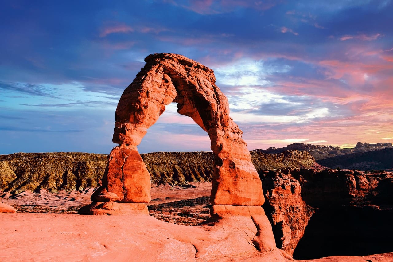
- Sunset at Delicate Arch
- Sunrise glow under Mesa Arch in Canyonlands
- The gooseneck bend of the Colorado River from Dead Horse Point
Why this plan
Flying into Las Vegas and out of Salt Lake City means you never backtrack, and the parks fall in a natural line from southwest to northeast. Zion gets two nights because its shuttle and permit hikes need time, and Arches lands on a full day so you can do Devils Garden early and Delicate Arch at sunset. Mid-October brings cool hiking weather, golden cottonwoods and thinner summer crowds.
Pace
Mornings start early to beat crowds and hike in cool air, with afternoons for driving between parks. Most drives are one to three hours, and the longest comes on the last day to Salt Lake City.
Daily Itinerary
Day 1: Las Vegas to Zion via Valley of Fire
Collect your car or RV in Las Vegas and drive north, detouring through Valley of Fire State Park for your first red rock. Continue on I-15 into Utah, remembering to set your watch an hour ahead. Stop at the Zion Canyon Visitor Center to pick up maps and shuttle info, then walk the flat Pa'rus Trail along the Virgin River to Canyon Junction for sunset light on the Watchman. Dinner is a short walk away in Springdale.
Stops
08:30Harry Reid International Airport · Las Vegas
60 min · one-way rental from about $70 a day plus drop fee
Picking up here gets you on the road before the midday heat.
Ask for a car with high clearance if you plan any dirt-road side trips.
10:00Valley of Fire State Park · Overton, Nevada
90 min · about $15 per vehicle
Nevada's oldest state park is a glowing introduction to Navajo sandstone.
Drive the White Domes road and walk the short Fire Wave trail if time allows.
15:30Zion Canyon Visitor Center · Springdale
45 min · $35 per vehicle or the annual pass
Rangers here give the latest trail, shuttle and Narrows conditions.
Park in Springdale and walk in; the visitor centre lot fills by mid-morning.
17:30Canyon Junction Bridge · Zion Canyon
60 min · free
The classic view of the Watchman peak glowing above the Virgin River at sunset.
Walk the paved Pa'rus Trail from the visitor centre to get here.
19:00Zion Canyon Brew Pub · Springdale
75 min · $20–$35
A friendly pub right at the park's pedestrian entrance with views of the canyon walls.
Sit on the patio for the last light on the cliffs.
Coffee and a breakfast sandwich in Las Vegas · Picnic from the cooler or a quick stop in St. George · Zion Canyon Brew Pub · Trail mix and fruit for the road
Day 2: Angels Landing and the Zion Narrows
Ride the first shuttles to The Grotto for Angels Landing, climbing Walter's Wiggles to Scout Lookout and, with a permit, along the chained spine to the top. Without a permit, Scout Lookout and the West Rim views are still spectacular. Lunch at Zion Lodge, then ride to the end of the line at the Temple of Sinawava and walk the Riverside Walk into the Narrows, wading upstream between towering walls for as long as you like. Return to Springdale for dinner.
Stops
07:15The Grotto (Angels Landing trailhead) · Zion Canyon
240 min · permit $6 plus $3 per person
One of America's most famous hikes, with a 450-metre climb to a knife-edge summit.
Start early to climb the switchbacks in shade.
12:00Red Rock Grill · Zion Lodge
60 min · $18–$30
The historic lodge's dining room is the only sit-down restaurant inside the canyon.
Take your drink out to the lawn under the giant cottonwood.
13:30Temple of Sinawava and the Narrows · Upper Zion Canyon
210 min · free; gear rental about $30–$60
After a paved riverside mile you wade up the Virgin River between walls 300 metres high.
Walk at least to Wall Street, about two hours upstream, where the canyon narrows dramatically.
18:30Oscar's Cafe · Springdale
75 min · $18–$30
A long-running Springdale favourite with big Mexican-inspired plates and a lively patio.
Arrive before 19:00 to avoid the dinner wait.
Early breakfast from a Springdale café or your room · Red Rock Grill at Zion Lodge · Oscar's Cafe · Energy bars and electrolytes for the hikes
Day 3: Zion tunnel to Bryce's hoodoos
Drive up the Zion–Mount Carmel Highway and stop just past the long tunnel for the short Canyon Overlook Trail. Continue through checkerboard sandstone and ranch country to Bryce Canyon, 1h45 away and about 1,200 metres higher. After lunch at the lodge, hike down from Sunrise Point through Queen's Garden and loop back up the Navajo Loop's Wall Street switchbacks. Finish at Inspiration Point as the hoodoos turn orange at sunset.
Stops
08:00Canyon Overlook Trail · Zion East
60 min · included in park entry
A short, exciting ledge trail to a viewpoint over lower Zion Canyon.
If the small car park is full, try again after a loop through the tunnel.
12:00Bryce Canyon Lodge · Bryce Amphitheater
60 min · $18–$30
The 1920s stone-and-timber lodge sits just steps from the rim.
After lunch walk five minutes to the rim between Sunrise and Sunset points.
13:15Sunrise Point · Bryce Amphitheater
150 min · $35 per vehicle or the annual pass
The trailhead for the Queen's Garden and Navajo Loop combination, the best short hike among the hoodoos.
Hike down Queen's Garden and up Navajo's Wall Street to save your knees.
17:30Inspiration Point · Bryce Amphitheater
60 min · included
Three tiers of viewpoints look over the densest part of the hoodoo amphitheatre.
Walk up to the Upper Inspiration Point for the widest view.
Breakfast in Springdale before the drive · Bryce Canyon Lodge · Valhalla Pizzeria by the lodge or Ruby's Inn · Hot chocolate at the Bryce general store
Day 4: Scenic Byway 12 to Capitol Reef
Bundle up for sunrise at Bryce Point, high above the amphitheatre. Then drive Scenic Byway 12, one of the most beautiful roads in the country, through Escalante canyon country to Lower Calf Creek Falls, a sandy 10 km round-trip walk to a 39-metre waterfall. Continue over the Hogsback ridge to Boulder for a late lunch at Hell's Backbone Grill. Cross the aspen-covered Boulder Mountain to Torrey and stop at the Capitol Reef Visitor Center.
Stops
07:00Bryce Point · Bryce Amphitheater
45 min · included
Sunrise here lights up the whole amphitheatre below you.
Arrive 20 minutes before sunrise for the best colour.
09:45Lower Calf Creek Falls trail · Grand Staircase–Escalante
210 min · $5 day-use fee
A gentle canyon walk past rock art and beaver ponds to a waterfall with a cool pool.
Look for the red pictographs on the canyon wall about halfway.
13:45Hell's Backbone Grill & Farm · Boulder
75 min · $25–$40
A celebrated restaurant cooking food grown on its own farm in one of America's most remote towns.
Hours change through the season, so check ahead.
16:15Capitol Reef Visitor Center · Fruita
45 min · $20 per vehicle or the annual pass
Get trail advice for tomorrow and see the cliffs of the Waterpocket Fold.
Ask about Gifford Homestead pie hours.
Coffee and pastries from Bryce Canyon City · Hell's Backbone Grill & Farm · A simple dinner in Torrey · Picnic snacks for Calf Creek
Day 5: Capitol Reef orchards to Goblin Valley
Start in Fruita, the old Mormon settlement where orchards still grow below the cliffs, and pick up a pie at the Gifford Homestead if it is open. Stop at the Fremont petroglyph boardwalk, then hike to the natural span of Hickman Bridge. Drive east through Hanksville to Goblin Valley State Park and wander among thousands of mushroom-shaped rocks. Finish in Moab, two hours north-east, with dinner at the brewery.
Stops
08:00Gifford Homestead · Fruita
45 min · free; pies about $8–$10
A restored 1900s farmhouse in the orchards, famous for its small fruit pies.
Walk the orchards behind it; deer graze there in the mornings.
09:00Petroglyph Panel · Highway 24
20 min · free
Boardwalks lead past Fremont-culture figures carved into the cliff over 800 years ago.
Bring binoculars for the higher carvings.
09:30Hickman Bridge Trail · Highway 24
100 min · included
A 2.9 km round trip climbing to a 40-metre natural bridge.
Start before 10:00; the slickrock warms up fast.
12:30Goblin Valley State Park · San Rafael Desert
90 min · about $20 per vehicle
A valley of eroded hoodoos you can freely scramble around.
Head out from the observation point and explore the first valley off-trail.
17:30Moab Brewery · Moab
75 min · $20–$35
Moab's long-standing brewpub, big enough to seat hungry hikers without a wait.
Order a sampler flight of their house beers.
A Gifford Homestead pie with coffee from Torrey · Picnic at Goblin Valley · Moab Brewery · Coffee in Torrey before leaving
Day 6: Arches from Devils Garden to Delicate Arch
Enter Arches at dawn and drive to the far end of the park to hike Devils Garden to Landscape Arch, one of the longest natural spans in the world. On the way back, stop at Balanced Rock and walk the loop to the North and South Windows and Turret Arch. Return to Moab for lunch and a rest during the heat. In the late afternoon, hike the slickrock to Delicate Arch for sunset, and walk down by headlamp.
Stops
07:00Devils Garden trailhead · Arches north
150 min · $30 per vehicle or the annual pass
The trail to Landscape Arch passes Tunnel and Pine Tree arches on the way.
Continue past Landscape Arch to Double O Arch only if you are steady on exposed fins.
10:15Balanced Rock · Arches central
20 min · included
A boulder the size of three school buses perched on a slender pedestal.
The short loop around it takes about 15 minutes.
10:45The Windows · Windows Section
75 min · included
North and South Windows and Turret Arch sit together on one short loop.
Take the primitive trail behind the Windows for a quieter return.
12:45Moab Diner · Moab
60 min · $15–$25
A classic Main Street diner that has fed Moab hikers for decades.
Try the green chile, which locals put on almost everything.
16:15Delicate Arch trail · Wolfe Ranch
180 min · included
Utah's icon, reached by a 5 km round-trip slickrock climb, glows red at sunset.
Find a spot on the bowl's rim and give others a turn under the arch.
Grab-and-go coffee and burritos in Moab before dawn · Moab Diner · Milt's Stop & Eat or another Main Street spot · Snacks and water for both hikes
Day 7: Canyonlands sunrise and the drive north
Leave Moab early for sunrise under Mesa Arch, when the underside of the arch glows orange. Drive to Grand View Point at the end of the Island in the Sky mesa for a view over a thousand square kilometres of canyons. On the way out, stop at Dead Horse Point to see the Colorado River's huge gooseneck bend. Lunch at a famous roadside tavern in Green River, then drive three hours to Salt Lake City for your flight.
Stops
07:00Mesa Arch · Island in the Sky
45 min · $30 per vehicle or the annual pass
A short walk to a cliff-edge arch that frames the La Sal Mountains at sunrise.
Photographers line up early; enjoy it with your eyes as much as your camera.
08:15Grand View Point Overlook · Island in the Sky
60 min · included
The tip of the mesa looks down over the White Rim and the canyons of two rivers.
Walk the 3 km round-trip rim trail beyond the main overlook.
10:00Dead Horse Point State Park · Dead Horse Point
60 min · about $20 per vehicle
A 600-metre drop to the Colorado River's dramatic gooseneck.
Walk the short rim trail to the Basin Overlook for a quieter angle.
12:30Ray's Tavern · Green River
60 min · $15–$25
A rafting-town tavern with river-runner photos on the walls and legendary burgers.
Order a burger with fries; portions are big.
17:00Salt Lake City International Airport · Salt Lake City
60 min · fuel to refill
Ending here saves the long drive back to Las Vegas.
Fill the tank before the airport exit; prices rise near the terminal.
Coffee and a breakfast burrito picked up in Moab · Ray's Tavern · At the airport or on the plane · Gas-station coffee on US-6
Where to stay
Stay in Springdale for Zion, Bryce Canyon City or the in-park lodge for Bryce, Boulder or Torrey for Capitol Reef and Moab for the last nights. If you travel by RV, farm and winery stays along the route make good overnights between parks.
- Springdale — walkable gateway town at Zion's entrance
- Bryce Canyon City — lodges right by the Bryce park entrance
- Boulder or Escalante — quiet stops on Scenic Byway 12
- Torrey — small base 15 minutes from Capitol Reef
- Moab — lively hub for Arches and Canyonlands
Getting around
A car or RV is essential, and every road on this route is paved. Inside Zion you use the free park shuttle; elsewhere you drive between viewpoints and trailheads. Allow extra time for the Zion–Mount Carmel tunnel, where large RVs need a paid escort.
Flight Suggestions
Fly into Harry Reid International Airport (LAS) in Las Vegas and out of Salt Lake City International (SLC), which saves a long backtrack. Both have rental desks; book a one-way rental well in advance.
Budget breakdown
- Per person
- $1,200–$2,000
- Estimated Cost
- About $1,200–$2,000 per person (two sharing a car), excluding flights
- Accommodation · $450–$850Six nights in motels, lodges or RV stays, per person sharing
- Car and fuel · $300–$450One-way rental with drop fee plus about 1,300 km of fuel, split between two
- Food and drink · $300–$500Diner breakfasts, picnic lunches and casual dinners
- Park fees and permits · $60–$90Annual pass, Goblin Valley and Dead Horse Point fees, Angels Landing permit
- Gear and extras · $60–$150Narrows gear rental, souvenirs, guided extras
Saving tips
- Buy the America the Beautiful pass at the first park; it pays for itself by the third
- Stock a cooler at a Las Vegas supermarket for picnic lunches
- Book refundable rates early, then re-check prices nearer the date
Weather
Expected conditions
Mid-October is clear and dry, with days around 20–24°C in Zion and Moab and 12–15°C at Bryce, where nights often drop below freezing. Rain is rare but can bring flash floods to canyons.
What to wear
Pack layers: a T-shirt for midday hikes, a fleece and a warm jacket for sunrise and evenings. A hat, gloves and a beanie make the Bryce sunrise far more comfortable.
Packing Suggestions
- Hiking boots with good grip
- Neoprene socks for the Narrows
- Warm puffy jacket and beanie
- Wide-brim hat and sunglasses
- Headlamp
- Cooler and reusable water jugs
- Trekking poles
Restaurant & Cafe Picks
- Zion Canyon Brew Pub (Springdale) — a local craft beer and a burger by the park entrance
- Oscar's Cafe (Springdale) — huevos rancheros or a pork verde burrito
- Hell's Backbone Grill & Farm (Boulder) — farm-grown seasonal plates in the middle of nowhere
- Moab Brewery (Moab) — burgers and pints after a hike
- Ray's Tavern (Green River) — a cheeseburger and fries on the way north
- Milt's Stop & Eat (Moab) — a 1950s burger stand with milkshakes
Local tips
Etiquette
- Stay on trails and slickrock; the black crust on desert soil is alive and fragile
- Yield to uphill hikers on narrow trails
- Pack out everything, including fruit peels
Getting around
- Zion Canyon Scenic Drive is shuttle-only most of the year; park in Springdale and walk in
- Utah is one hour ahead of Nevada; set your clock after the border
- Watch for deer and cattle at dusk on Byway 12 and Highway 24
- Arrive at Arches before 07:00 to avoid entry queues
Tourist traps to avoid
- Paying for photo tours at Mesa Arch when the sunrise is free and a short walk
- Overpriced gear packages; rent only what the Narrows conditions require
- Driving straight through Byway 12 without stopping; it is the best scenery of the trip
Safety Notes
- Never enter slot canyons or the Narrows if rain is forecast anywhere upstream
- Angels Landing has sheer drops; turn back at Scout Lookout if you feel unsure
- Dehydration is the most common rescue; drink before you are thirsty
- Fill up with fuel before long empty stretches like Hanksville to Green River
Good to know
- Transit
- America the Beautiful pass, $80 per car
- Tipping
- 18–20% at sit-down restaurants
- Tap water
- Safe; carry plenty on every hike
- SIM / eSIM
- Patchy signal in parks; download offline maps
- Plug
- Type A/B, 120 V
- Sunrise / sunset
- 07:32 / 18:50
Bookings
- One-way rental car or RV, Las Vegas pickup and Salt Lake City drop-off
- Angels Landing permit through the seasonal or day-before lottery on recreation.gov
- Arches timed-entry reservation if the system is running for October
- Lodging in Springdale and Moab early; both fill up in autumn
- Narrows dry-suit or dry-pant rental in Springdale
Documents
- Driving licence, plus an international permit if it is not in English
- ESTA or US visa for international visitors
- Printed or offline copies of park permits and reservations
Money
- Cards accepted almost everywhere; carry a little cash for small-town stores
- The $80 annual pass covers all five national parks; state parks charge separately
- Fuel up whenever you pass a station on Byway 12 and Highway 24
Health & safety
- Carry at least 3 litres of water per person on long hikes
- Check the flash-flood forecast before entering the Narrows
- Altitude at Bryce reaches 2,700 m; take it easy on the first climb
Emergency info
- Emergency number
- 911
Useful phrases
- Trailhead — where a hiking route starts
- Pull-out — roadside parking spot
- Flash flood warning — stay out of canyons
- The check, please — the bill, please
Local guides and tips for United States
- SeattleTravel tips for Seattle
- Boulevard ParkTravel tips for Boulevard Park
- HighlandTravel tips for Highland
- New YorkTravel tips for New York
- PineTravel tips for Pine